Saturday, November 24, 2012

Treasures of the Contraband

Local legend claims that the pirate Jean Lafitte buried treasure somewhere along Contraband Bayou. The house where I grew up is located near its banks and I spent countless hours roaming its shores and canoeing its waters. While the bayou never revealed any gold or jewels to my inquisitive eyes, it features prominently in a treasure trove of childhood memories.

During this year's Thanksgiving holiday I was able to paddle it again for the first time in many years. Thanks to the passage of a cold front the night before, the air was chilly and the water level was low. But the breeze was light and the sun was warm, so we decided it was time to rediscover the bayou.

The friendly folks at the Bowtie Marina were generous enough to let us use their boat ramp to launch our kayaks. Just as we exited the marina, I spotted an osprey perched in a tree nearby. It took flight before we could get very close, but it set the tone for the afternoon's wildlife spotting. It was a day for the birds.


We headed upstream, passing under the Prien Lake Road and I-210 bridges. Despite the fact that we were going upstream, we found that the current was going in the same direction. Unless there's been a recent rainfall, any current in this bayou is a function of wind and tide.

Along way way we saw ospreys, herons, egrets, cormorants, kingfishers, and more. And of course we saw our fair share of wooded shores and lovely homes as well. We also ran across more than our fair share of dogs who seemed to feel that kayaks were almost as much fun to bark at as squirrels.

We finally turned around near Sale Street as the afternoon was starting to wane. We headed back downstream (against the current) and arrived at the marina just in time to reload the boats before their closing time.

While some things have changed along the old bayou, much of it looked and felt comfortably familiar -- and that's a good thing. It's heartening to know that the setting of so many treasured memories is still around, and not only in my mind.


More Pictures from Contraband Bayou

Monday, October 29, 2012

Lost Maples: Sometimes Green is a Fall Color


The state of Texas is known for many things, but having beautiful fall colors isn't generally numbered among them. One place that bucks that reputation is the Lost Maples State Natural Area, where the ancient stands of big tooth maples growing in the canyons often put on quite a show.

This year the cold weather arrived too late for my scheduled visit. Things were still green and growing when I arrived with no leaf turn to be seen anywhere.

Oh well! For my money, green's a pretty color too and I thoroughly enjoyed my visit. I arrived early while the morning was still quite cool and hiked both the east and west trails, taking in the views from the bottoms of the canyons and the tops of the hills.

I highly recommend hiking this park in either the spring or the fall. And if you time your fall trip just right, just maybe you'll catch the maples in their full glory.

More Pictures from Lost Maples

Saturday, October 27, 2012

Blown on the Bayou

I think Mother Nature has it out for me this fall. First, she chased me from Lake Raven with clouds and cold winds during my first paddle of the season. Then she lulled me into complacency with the return of a few weeks of summer-like weather. But after I scheduled this paddle to Pickett's Bayou for my kayaking meetup group, she decided to hurl the first strong cold front of the season at southeast Texas.

The cold dry air started blowing in on the night before the paddle and the RSVP list quickly evaporated. The prospect of a low temperature in the the forties coupled with strong north winds was just a bit too much for most of our members. By launch time, only three of us remained.

Yes, the morning air was cold. And yes, the north wind was blowing. But otherwise it was an amazingly beautiful day. The sun was shining brightly from a flawless blue sky.

The paddle south was uneventful up to the point where we reached Jac's Island. We took the fork toward the right, thinking we'd find a narrow channel there which we could follow toward the Old River. We learned that satellite imagery can sometimes be deceiving, as we quickly ran out of water and were forced to turn back.

Instead we took the left fork, passed Jac's Island, and continued southward toward the narrows. As we entered the narrows, we noticed a moderately strong current pulling us forward. Upon exiting the south end of the narrows and reaching the Cutoff to the Trinity, we found ourselves faced with a small waterfall at the pipeline crossing. The strong north winds associated with the cold front had pushed enough water out of Trinity Bay that the bayou was slowly being drained.

We'd harbored some thoughts of continuing into the cutoff and beyond, but there wasn't any clear portage path around this unexpected waterfall, and we weren't confident the narrows would remain passable if the water level dropped much more. We'd run out of water once again!

We retraced our path through the narrows and then landed briefly on Jac's Island. It gave us a chance to stretch our legs a bit and examine the animal tracks in the sand. After a brief exploration, we returned to our kayaks and headed for the launch. Since the afternoon sun had warmed the air a bit, the headwinds had lost their bite and we made it back in good spirits.

While it may not have been the perfect day for a paddle, I can handle as many imperfect days like this as Mother Nature wants to give me!


More Pictures from Pickett's Bayou

Saturday, October 6, 2012

Fall Arrives at Lake Raven

While I thoroughly enjoy my summer excursions, there's no denying the heat and humidity that characterize most paddles along the gulf coast in the summer. By the time fall arrives, I'm generally ready for a change.

The temperature was comfortably warm as we headed toward Huntsville on this Saturday afternoon. We exited I-45 just south of town, turned west on the Huntsville State Park access road, and soon disappeared into a sea of pines.

The park was hopping, with the usual compliment of campers and boaters being joined a group of mountain bikers there for a race. We made our way down to the boat ramp, unloaded, and shoved off into the relatively uncrowded waters of Lake Raven.

The first couple of hours of our paddle were lovely as we explored the western lobe of the lake. We hoped to spot an alligator if we could. We couldn't. But with the peace and quite of the lake broken only by the calls of birds from the surrounding woods, it was difficult to be too upset about that or anything else. As we circled the lake, we nosed our way into various little inlets. In many of them we disturbed small gatherings of ducks or other water birds. In one we ran across a huge swarm of hornets that had taken over a wood duck nesting box. By the time we got close enough to tell what they were, they were starting to look agitated. Needless to say, we made a hasty retreat.

As we made our way over to the eastern side of the lake, Fall started taking itself a bit more seriously. The clouds thickened and the wind picked up out of the northwest. Soon the temperature had dropped 10 or 15 degrees and we were paddling into a cold headwind that was raising goosebumps all over us. A short time later we reached a unanimous decision that we'd paddled enough and headed back to the warmth of my car.

I'm glad you're here, Fall, but next time we visit I'm going to dress a bit more warmly!

Saturday, September 15, 2012

Closing out Summer on Luces Bayou

What a summer it's been for kayaking! The weather has been warm, but not as scorching as last year. And since we've been blessed with more rain, there's been much more water to paddle in the local lakes and streams.

Along the way I've gotten to revisit all of my favorite destinations from last year and I've discovered a few new ones like Luces Bayou. So it's fitting that I spent the last Saturday of summer paddling its waters with one special kindred spirit.

It was overcast and relatively cool on Saturday morning when we reached Ponderosa Marina. The calm and quiet were in stark contrast to my last visit when both the Houston Canoe Club and Houston Kayaking Meetup group were arriving at about the same time. We unloaded our boats, shared a quick breakfast, and then headed upstream.

Other than a handful of fisherman we had the bayou mostly to ourselves. Unless you count the herons. And the egrets. And the kingfishers. And the woodpeckers. And . . . well, you get the idea.

As the morning progressed and we made our way farther upstream, the clouds burned off and the day became quite warm. Now and then we'd pause near the cypress-shaded banks, enjoying the cooler air and soaking in the quiet -- interrupted only by the occasional call of a bird.

Eventually we turned our boats and made our way back downstream at a leisurely pace. We stopped briefly at the local "nude beach" [PHOTO REDACTED] and then finally returned to the marina.

We loaded the boats but somehow weren't quite ready to bid farewell to the bayou. As we lingered, we snacked on some cool slices of apple that tasted especially sweet in the warmth of that late summer afternoon. It was a perfect last paddle to punctuate a wonderful summer on the water.

More Pictures from Luces Bayou

Saturday, September 8, 2012

Armand Bayou Delivers, but Where Are the Alligators?

The unspoiled surroundings and plentiful wildlife of Armand Bayou's upper section have made it a favorite paddling destination for as long as I've had my kayak. This weekend's paddle was true to form, with one notable exception.

After launching from Bay Area Park shortly after sunrise, we headed upstream with the goal of paddling until we ran out of bayou. The surface of the water was relatively calm except where it was disturbed by the leaping of mullet and skittering splashes of startled minnows. In the shallows, herons, egrets, and other wading birds patiently scanned the waters for their prey, while ospreys did the same from the treetops.

As the bayou nears Red Bluff road, the channel forks. Straight ahead, the bayou crosses under the road and becomes ditch-like in character. But to the left, the channel begins to narrow and wind. During past paddles, fallen trees have always blocked the left channel not too far beyond the fork, but this visit brought a pleasant surprise. The one fallen tree that completely blocked the bayou had enough air space on the right to allow a paddler to squeeze beneath it. Beyond that point the bayou was a veritable obstacle course of partially submerged trees, but always with a path through for the careful paddler.

We soon passed the farthest point I'd reached before and continued weaving our way through the narrow shaded channel. We covered about four miles and crossed under a set of high voltage power lines before an obstruction we couldn't readily pass forced us to turn around. After "reloading" one kayaker who ended up in the water after a close encounter with a spider, we headed back toward the launch.

One thing we didn't see during this paddle was an alligator. And I didn't see one during my previous paddle on the Old River, or the one before that at Pickett's Bayou, or the one before that at Luces Bayou, or even the one before that at Sheldon Lake. In fact, I don't think I've run across an alligator all summer. That seems odd, since these are all places I would expect to see them. Maybe I've just been unlucky? Maybe it's because I've typically been paddling with larger groups? I'm not sure, but I hope the pattern won't continue indefinitely. Seeing alligators swimming the channel or sunning on the bank provides a welcome connection to the wild!

EDIT: I'd no sooner posted this blog entry than I noticed one of my fellow paddlers did get a picture of an alligator floating suspended in the water with only eyes and nose showing. Apparently the vanguard of the group got a fairly long look at him before he finally gave up the staring contest and submerged. So, maybe all is as it should be!


Wednesday, September 5, 2012

Revisiting the Calcasieu

By the time the Calcasieu River reaches the city of Lake Charles, man has tamed much of its natural character. The banks of Lake Charles proper host a casino, a civic center, a marina, and a collection of grand homes. And the river itself has turned tidal and brackish, courtesy of the deep water ship channel which follows its course all the way down to the Gulf of Mexico. The fishing here can be good, but for speckled trout and red-fish rather than bass. But not too far upstream, at places like Sam Houston Jones State Park, the more natural character of the river still shines through.

The park is a great place to picnic, to feed the ducks, or to wander the wooded trails through glades of long leaf pines and various hardwoods. Visits here were a staple of my childhood. Often we'd come by boat, launching at Lake Charles, passing the Salt Water Barrier, and then following the cypress-lined channel upstream to the park.

On my most recent visit to Louisiana we made it back up to the park for the first time in many years. Time appears to have largely healed the scars left by Hurricane Rita and the park was green and vibrant.

Just inside the park entrance we saw a cotton-tailed rabbit foraging beside of the road, unconcerned by our presence. Next a deer wandered out to look us over - apparently looking for a handout.

Once we finished a driving loop through the park we left the car behind and walked a trail around the pond. The nutria and alligators hid from us, but we saw a few wading birds in the pond and numerous squirrels and birds in the surrounding woods.

After the walk we settled down for a picnic by the river. A squirrel arrived on the scene, hoping to capitalize on any unwanted (or just unattended) dainties. A collection of love bugs and ants tried to crash the party but we did our best to un-invite them. By the time lunch was finished, we decided the occasional hints of breeze weren't enough to compensate for the growing heat and we packed up for the air conditioned drive home. Still I was glad to revisit an old friend, even on a rather toasty late summer day.

Sunday, August 26, 2012

In With The Old

At this point in my life, I have no idea how many times I have traveled Interstate 10 between Houston and the Louisiana border. I was raised in Lake Charles while my grandparents were still living in Houston, so that stretch of road was intimately familiar to the family station wagon. Now that I call Houston home and my parents remain in Louisiana, my RAV4 has traced the same path in reverse countless times. And on every trip, about an hour east of Houston, I have crossed a wide bridge bearing the legend Old and Lost Rivers.

In moments of idle fancy I have wondered which part was old and which was lost, but the flashes of curiosity never went any farther -- until I bought my kayak. Now I see the area with different eyes. The surrounding Trinity River basin is a natural treasure with countless options for paddling. Over the centuries, the Trinity has meandered over miles of bottom-land on its way to the bay. As it has wandered, it has left behind a maze of bayous, sloughs, and old river channels like the Old and the Lost.

I have already already written about my paddles in the Trinity National Wildlife Refuge at Champion Lake. This weekend I finally had the chance to to get better acquainted with the Old River.

We launched our kayaks at the Old River bridge on FM1409 and headed slowly upstream. The water was placid except for the occasional roll of a gar. The banks were lined with cypress, pecan and other hardwoods, often with an understory of palmetto. There were occasional signs of development: a ranch, a few houses around a golf course, a few pipeline crossings. But mostly there were heaping helpings of peace and beauty.

As we continued upstream, the channel slowly narrowed and the welcome canopy of trees closed in overhead. After a little over three miles we turned back toward the launch and enjoyed the scenery a second time on the return trip.

On some cooler day I still want to explore the area downstream section. And then of course there's the Lost River. And Lake Charlotte.  And . . .

More Pictures from the Old River

Sunday, August 12, 2012

Seeking a Little Refuge on a Scorching Summer Day


I have been plotting a return to the Trinity National Wildlife Refuge since my first visit last year. At that time the drought of 2011 had already taken its toll on Champion Lake but we had a wonderful paddle on Pickett's Bayou on the last cool Saturday in May.

While I knew an August weekend was unlikely to be even remotely cool, I wanted to see Pickett's Bayou again and paddle Champion Lake for the first time.

The day started out warm and progressed rapidly to hot, relieved slightly by an occasional breeze and patches of shade along the bayou's banks. The water level in the bayou was a bit higher than on my last visit but otherwise the paddle south through the hardwood forest of the refuge had the same lovely character.

As we continued south past the sand bar and approached the Cut Off, the bayou narrowed and the trees provided a welcome canopy overhead. And we weren't the only ones who seemed to like the area. A whole colony of banana spiders had spun webs across the channel above our heads. A bit surprisingly, we also found that we were paddling against a current as we proceeded south.

Once we reached the Cut Off, we turned east toward the Trinity River. We found the gate closed at the the Corp of Engineers' "Structure A", but a fair amount of water was still pouring through, thus providing the current we paddled against coming down. We took the closed gate as a sign and turned around. We started back toward the launch with a respectable current helping us along until the bayou widened again.

It was approaching noon before everyone was back on dry land. By then, the heat had taken its toll on the group's enthusiasm for more paddling. Some packed up and headed out, while a few of us gathered in the shade for a picnic lunch.

By the time lunch was over, only two of us remained to take a look at Champion Lake. I had hopeful visions of gliding through the shady groves of submerged cypress trees but it wasn't meant to be. While the lake has plenty of water, it has been taken over by various types of vegetation. The only open water we could find was in the largely unshaded area of Big Caney Creek on the northeast side of the launch. We paddled until we ran out of water and then had to concede defeat. I fear that a full exploration of Champion Lake is going to have to wait until next spring!

More Pictures From the Trinity National Wildlife Refuge

Saturday, August 4, 2012

Lake Conroe: A Visit To Wildwood Shores

The weekend brought the chance to visit a new area of Lake Conroe. This time we launched our kayaks along Stubblefield Lake Road and paddled south. We followed the old river channel as it made its winding way through the upper section of the lake bed. Eventually the channel reached slightly deeper waters and the lake opened up before us.


We turned east and made our way over to the only development on this section of the lake, the aptly named Wildwood Shores. After entering via a drainage culvert, we explored the canals of the subdivision and the lower section of East Sandy Creek before making the return trip to Stubblefield.

More Pictures From Lake Conroe

Saturday, July 28, 2012

Lake Conroe: Cagle to Stubblefield

The key attraction of the northern section of Lake Conroe is the scenery of the Sam Houston National Forest which surrounds it. The plan for today was to launch at the Cagle Recreation Area, paddle up to the lake's northern edge, and then continue up the river channel to the launch near Stubblefield Lake. We shoved off from Cagle under an overcast sky a little after eight in the morning. A light breeze was in our faces as we turned north, passed under the FM1375 bridge, and crossed over to the west side of the lake. 

As we followed the shoreline northward, the sights and sounds of civilization began to fade away. The sounds of cars crossing the bridge were replaced by the calls of birds: the irritated croak of a blue heron as we disturbed his fishing, the cheerful song of a male cardinal perched near the edge of the lake, the trill of a pileated woodpecker deep in the woods. The morning clouds began burning away, leaving behind a clear blue sky and bright sunshine.

Once we reached the northernmost section of the lake, the shore became lined with a band of rattlebushes, a legacy of last year's drought. With its low point last year being almost 6 feet below today's level, much of the lake bed in this area was exposed and hospitable for growth. As we continued forward, the rattlebushes closed in and the open water disappeared completely.

We knew that the deeper and presumably unobstructed channel of the West Fork was nearby, but how could we get to it? One option was to backtrack and see if we could find the channel entrance on the east side of the lake, in the direction of Wildwood Shores. But retreat is always bitter. Instead we looked around until we found a spot where the rattlebush thicket was less dense and there was a hint of open water in the distance. From there we set off "cross country" through the bushes using a combination of push-polling and dragging ourselves from bush to bush -- all while being showered with bits of leaves, seed pods, and the occasional spider.


Then suddenly we were through into the open waters of the West Fork. After that it was an easy paddle up to Stubblefield Lake. We picked a shady spot on the shore to relax for a bit and eat a picnic lunch. Thus fortified, we returned to the water. We dodged the ever present fishing lines and crossed under the bridge at Stubblefield Lake Road to continue upstream. We'd only gone about a half mile more when the warmth of the afternoon overwhelmed our collective sense of adventure. We turned back to the launch where we found a group of butterflies were waiting to welcome us.


Sunday, July 22, 2012

Cruising the Shaded Waters of Luces Bayou

After hearing good things about Luces Bayou from people in my paddling group, I finally got a chance to visit. It proved to be a great place to paddle on a warm summer day. The bayou is fairly wide at our launch point at Ponderosa Marina. From there you can either paddle downstream toward Lake Houston or upstream toward the bayou's headwaters.

We chose the upstream option and found ourselves in a gradually narrowing channel heavily shaded by cypress trees. We paddled beneath a couple of bridges and past a few houses and camps, but overall the setting is very natural and unspoiled. After paddling about three and a half miles, the bayou was obstructed by some broken concrete, an old metal culvert, and some fallen trees. We decided that was the right time to turn around, but I'll definitely be coming back.

Wednesday, July 4, 2012

Independence Day on Lake Houston

I marked this Independence Day with my very first visit to Lake Houston. A group of us gathered at Deussen Park to paddle, picnic, and celebrate the birth of our nation.

The water was fairly calm during our morning paddle and we explored a pretty little tributary off to the west of the park.

Later in the day the wind and and assortment of power boats stirred up the water but that didn't prevent us from making an afternoon voyage to the east, past the spillway and to the other side of the lake.

Mother nature even chipped in with some fireworks, as a little thunderstorm chased us back to the park a the end of our second paddle. Overall, it was a great July 4th!

More Pictures from Lake Houston

Sunday, June 24, 2012

A Quick Trip to Sheldon Lake

It feels like I was everywhere but on the water during June. First up was a visit to my parents in Louisiana. Next was a fairly standard visit to the office up in Richardson, Texas. Then out of the blue came a trip to White Plains, New York. And just like that,the month was almost over.

Before the last days could slip away, I scheduled a quick outing to Sheldon Lake. I was a bit surprised to find the water level down a few feet despite the wet weather. When we talked to the ranger during our picnic lunch, we found they had intentionally lowered the level to enable some road construction at the new park entrance off Garrett Road.

Partly because of the lower water levels and partly due to the normal summer cycle, the lotus and other water plants had grown up significantly since my last visit, reducing the amount of water open for easy paddling.  Still, it was very welcome to get out on the water and enjoy the sight of the egrets, herons, ibis, spoonbills and other water birds that make their homes on this lake.

My resolution for July is spend many more hours on the water!

Saturday, May 26, 2012

Lake Conroe: North to Cagle


Memorial weekend provided a perfect opportunity to return to Lake Conroe. The lake suffered greatly during last year's drought but winter and spring rains have nearly restored it. We launched from private property in the Walnut Cove subdivision and headed west down a canal.

Water birds like this Great Blue Heron were out in full force as we paddled the sheltered waters. Once we reached the open lake, power boats and jet skis became more common sights.

The wind freshened as we passed in front of the Corinthian Point Yacht club and headed north. Soon we were leaving the jet skis and development behind and entering the bounds of the Sam Houston National Forest.

A convenient beach beckoned and we paused for a rest, a snack, and for some of us, a swim. Once everyone was sufficiently recharged, we headed north again. Aside from a few scattered fishermen, we had the lovely scenery of the lake more or less to ourselves.

About the time that the day started to grow uncomfortably warm, the dock at the Cagle Recreation Area came into view. We made our way to shore to enjoy some shade and a snack while waiting for our ride back to Walnut Cove.

What a great paddle! Next on my list for this lake is the run from Cagle up to Stubblefield.

More Pictures from Lake Conroe

Sunday, May 13, 2012

Seeking Carpenter's Bayou

Spring paddling season is off to a good start here in Houston. Generous winter and spring rains have mostly refilled the nearby lakes and streams that were depleted by last summer's drought. And I've been lucky enough to make it out onto the water a number of times. I had my first experience with surf paddling (and some surfing lessons) down at Surfside Beach on a very windy day. I paddled about ten miles on Armand Bayou, upstream and down from Bay Area Park. I attended Austin Kayak's spring "Demo Days" event and was able to try out a number of new boats. And I glided through the cypress trees and water lilies on Sheldon Lake for the first time since last summer when low water led to its closure.

You might be wondering (if you aren't, please humor me) why I haven't posted anything if I've been doing all of this paddling? Good question! One reason could be because all of the posts from my Ozark adventures depleted my stock of words.

But the larger reason is that this spring most of my trips have been with a group from the Kayaking in Houston Meetup. It's been great meeting new paddlers and adding a larger social dimension to paddling, but it has cut down dramatically on my picture taking. It's partly that the noise of a large group scares away some of the wildlife I might have photographed. But also as I have gotten more involved with organizing these outings, I've taken less time to "stop and photograph the roses" (or water lilies, as the case may be). I'll have to work on that.

After paddling with the group on Sheldon Lake this Saturday, I went back for a solo paddle on Sunday. In my prior visits to the lake, I've never been able to paddle all of the way up to the lake's northern boundary and beyond into Carpenter's Bayou. During my first few trips, I didn't even try. And then as last summer progressed, the water levels got too low and the vegetation too dense to allow it.

My trip with the group on Saturday led me to believe things had changed. The water level in the lake was only about a foot and a half below the maximum and the vegetation levels were well below their full summer density. I set out from the launch on Pineland Road and headed generally north, more or less hugging the western boundary of the lake. The first couple of miles were quite easy, as I mostly just retraced my route from the day before. But the last mile grew a bit trickier. The water depth kept decreasing as I traveled farther north. In addition to the beds of water lilies, there were areas of aquatic grasses which clogged the channel, tangling my paddle blade as I tried to pass through.

At one point I thought I'd reached a dead end. I could see the power lines along Garrett road up ahead, but in front of me was a fairly dense bed of reeds growing in the shallow water. I didn't want to give up but didn't see any reasonable way through. Finally I stood up (very carefully) in my kayak for a look around. What a difference a few feet of height makes when in a marshy environment! From the higher vantage I could see that there was actually quite a bit of open water in front of the Garrett Road bridge, and that it appeared to extend to a point not too far to my left. I backtracked twenty or thirty yards and then picked my way towards where I'd seen the open water, forcing my way through a few narrow bands of reeds and aquatic grasses along the way. Then suddenly there was only open water (relatively speaking) between me and the bridge. Victory!

I cruised under the bridge, needing to duck slightly, and Carpenter's Bayou opened up before me . . . and then closed again almost as quickly. After only a brief stretch of open water, the left side of the channel was blocked by masses of tall flowering grasses. To the right, the channel passed into a fairly dense grove of cypress trees. I made my way into the trees, tied up to a cypress knee, and had lunch while listening to the chatter of the birds.

After lunch I explored the cypress grove a bit more but didn't find anything resembling a clear channel to proceed upstream. Eventually I turned south again and picked my way slowly back into the more open waters of Sheldon Lake.

On the way back to the launch I took a side trip to the spillway and landed there, taking a few more minutes to look around enjoy the day before heading for home after a very enjoyable seven mile paddle.

More Pictures from Sheldon Lake


Sunday, April 1, 2012

Spring in the Ozarks: Farewell

On the final full day of my trip, I slowed things down a bit. I spent a leisurely morning at the cabin, ate an early lunch, and then drove through Ponca and up the mountain behind it. The activity of the day was a Zip Line Canopy Tour. Jumping off of the platform for the first time didn't turn out to be scary, but my stomach did a flip the first time I reached maximum speed, hit the low point on the cable, and started back up. It was all down hill from there (sorry, couldn't resist). The only major down side to the whole experience was that when we were finished, they informed us that they had another zip line course with runs that are faster. It's not fair to tell me that on my last day!

The canopy tour was the last major event on the agenda for the trip. I headed back to Foggy Hollow, cleaned up a bit, and visited the cafe for a last delicious dinner. After that, it was time to start packing my things for an early departure the next day.

When Sunday morning came, I was up before the birds and had one last breakfast on the back porch. As I dressed and loaded the car, the mist was slowly lifting from the valley. Too soon I was saying farewell to my home away from home and heading up the driveway for the last time, at least for this trip.

I turned toward Jasper and then south on Arkansas Highway 7. Like the highway I arrived on, "Scenic 7" is winding and steep and gave me a good chance to say farewell to the Ozarks before depositing me back on I-40 near Russellville. The remainder of the trip home was uneventful. By the time I'd covered around 500 miles I was running out of patience with Sunday drivers, but by around mile 580 I was pulling into my own driveway and found my comfortable house waiting for me.

I was happy to be off the road and in some ways I was glad to be home. But I carried good memories of the Ozarks back with me, and perhaps left a bit of myself behind in those valleys.

Friday, March 30, 2012

Spring in the Ozarks: Lost Valley

I returned to Lost Valley for the last hike of my trip. It's a relatively easy trail in a very accessible location but there's a great deal of beauty per acre. While I enjoyed it during my fall visit a couple of years ago, the greater volume of running water this time made it even more special.

The trail follows Clark Creek as it winds through the wooded valley, passing the Natural Bridge and Cob Cave before finally reaching Eden Falls.

On this visit I headed straight back toward the main falls, but I was sidetracked by the sound of falling water to the left of the trail. A short scramble led me to this pretty little moss-covered cascade. I paused to admire and then returned to the main trail. A few minutes later I could hear and see Eden Falls in front of me.

After enjoying the falls from below, I climbed the steeper trail to the mouth of Eden Falls Cave where Clark Creek emerges to create the falls. 

I'd brought flashlights with the intention that this time I'd make my way to the underground falls hidden at the back of the cave. I did make  it deeper into the cave than on my prior visit, but I chickened out at the point where the cave height reduced me to a crawl.

After retreating from the the cave and taking another opportunity to admire the falls, I worked my way back to to the Natural Bridge. I climbed down into the creek bed and worked my way through the bridge from the rear until I had a view of the pool beneath it. Then I returned to the trail and looped around to get this lovely frontal view of water pouring from beneath the bridge.

From here it was just a leisurely stroll back to the trailhead. The popularity of this little valley is such that despite it being the shortest hike I took during trip, it's also the trail where I saw the most people. There wasn't exactly a crowd, but periodically the valley would echo with the excited sounds of children's voices.

While I'm often a fan of peace and solitude, I couldn't help but smile as I listened to them. After all, if my folks hadn't planted the love of the outdoors in my heart by bringing me to places like this as a child, maybe I wouldn't have been in Lost Valley at all.

More Pictures of Lost Valley

Wednesday, March 28, 2012

Spring in the Ozarks: Smith Creek Preserve

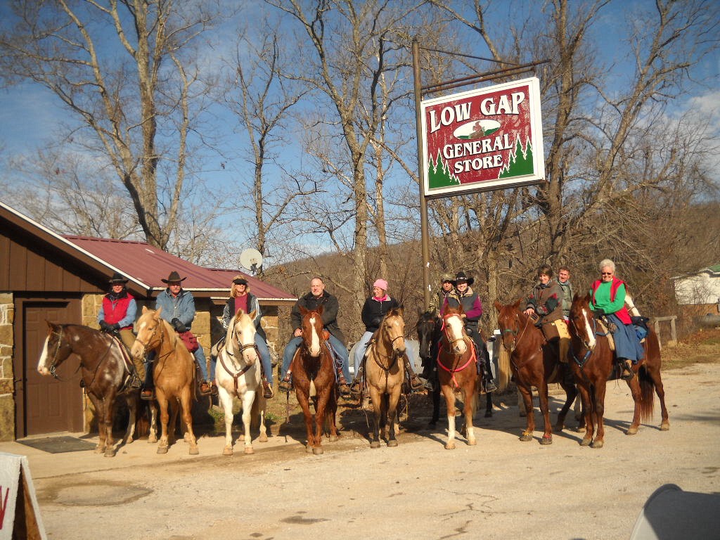
Luck was with me in a couple of different ways on Wednesday and both related to the Low Gap Cafe. The cafe opened a few months ago in an unassuming building that once served as the Low Gap General Store. It is closed on Monday and Tuesday so this was my first real chance to try a meal there despite passing it on the way to my cabin every day.

My first bit of luck was in choosing to eat there at all. My order on this first visit was just a sandwich and fries, but the sandwich was especially tasty and the fries were cooked perfectly. I got the idea that somebody at the cafe took pride in their food. After that I ate one meal per day there. From the hamburger to the filet mignon, I was never disappointed and I never went back to the Ozark Cafe. My only regret was that I had to pass up the triple chocolate cake due to a Lenten sacrifice.

Another notable thing about the Low Gap Cafe (aside from the hitching post incident mentioned here) is that they feature free WiFi in an area rather starved for Internet access. I was using their WiFi to do a bit of research on hiking destinations when good fortune smiled for a second time. A man named Michael Dougherty approached me and introduced himself. He is the president of the Buffalo River Chamber of Commerce and an avid photographer.

In preparing for my Monday and Tuesday float trips, I had already made use of some great information from his web site including GPS-annotated topological maps and river level references. Michael joined me at my table and we talked hiking and photography for about twenty minutes. Among other things, he said that the chance for a spring hike at the Nature Conservancy's Smith Creek Preserve was an opportunity not to be missed. The preserve protects 1,226 acres along Smith Creek above Boxley Valley. In addition to its surface beauty, it sits above Sherfield Cave which is home to Arkansas's largest population of Indiana bats. Since I had already been considering a visit to Smith Creek, his advice sealed the deal.

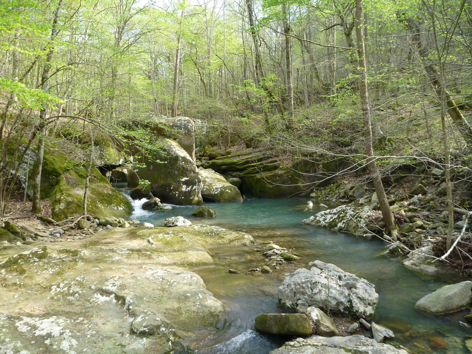
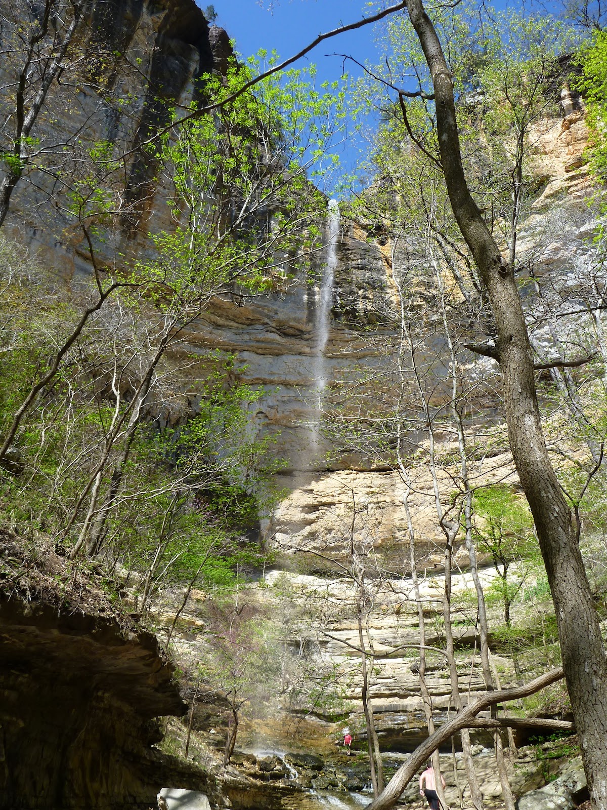
Once I finished my lunch, I packed my gear and headed for the preserve. When I arrived at the trailhead, I had the entire place to myself. My first goal was to find  my way to QuiVaLa Elise Falls. Using the directions from Tim Ernst's Arkansas Waterfalls Guidebook, I followed a fairly faint path (really more of an overgrown old jeep trail) until I reached a dry creek bed at the bottom of a hollow. After following the creek bed for a time, a small stream joined from the left and I heard the sound of falling water. A short scramble up this stream led to the waterfall on the right.

I soaked in this view for a time, then climbed back out of this hollow and followed the main trail downhill into another one. As soon as the path reached the bottom of the second hollow it turned and ran along Smith Creek for several miles. As the trail made its way through the woods, it crossed smaller streams coming to join the creek and passed little springs, sinkholes, wildflowers, dogwoods, redbuds, butterflies, and more.

The most striking portion of the hike was a section of the creek where huge boulders and a fractured limestone bed created a series of cascades. It was breathtaking. I clambered over the boulders to explore the cascades from all angles, then continued down the trail until it finally crossed the creek and faded away away into the woods.


I was in no hurry to leave, but eventually I retraced my steps back to the trailhead. A vehicle from Missouri was parked there when I returned, but I never saw the driver or anyone else. It was truly an afternoon of peace and beauty.

More Pictures from Smith Creek Preserve


Tuesday, March 27, 2012

Spring in the Ozarks: Buffalo National River

At the heart of this trip was the beautiful Buffalo River. From its headwaters in the Ozark National Forest to its confluence with the White River, this stream flows clear and unobstructed over its entire length.The headwaters are protected by the National Forest Service as a Wild and Scenic river. The lower 135 miles are managed by the National Park Service and were designated as the country's first National River (see map).

On my first and second full days in the area, I rented a kayak and paddled the ten mile stretch of river from Ponca to Kyles Landing. Heavy rains the prior week had sent the upper Buffalo into flood stage for a few days, but by Monday the water levels had receded enough to offer an ideal float.

In this stretch, the river's turquoise waters flowed through forested valleys, past steep limestone bluffs, and through of a series of moderate rapids.


Along the way the river passed numerous creeks and sandbars that offered opportunities for relaxation and exploration.

One other thing I found as I floated along is a collection of really friendly people. Other paddlers were eager to tell me about their favorite sections of the river, their favorite trails and waterfalls, and some of them, their life stories. And on the couple of occasions where a rapids got the better of someone, they were also eager to help gather up lost possessions before they floated away.

On my fourth full day I returned to hike the Buffalo River Trail from Ponca to a bit beyond Steel Creek and back. The trail wound along the hillsides and bluffs, giving me a chance to enjoy the Buffalo from a slightly different perspective.


More Pictures from the Buffalo National River